After doing a few back to back bushwalks, we wanted to do a coastal walk for a change and decided to visit Bouddi National Park which is renowned for its magnificent beaches and breathtaking views. Bouddi Coastal Walk from Putty Beach to MacMasters Beach is said to be one of the best walks in Central Coast which is 8 km one way. Our challenge was to find a loop walk that covers the best parts of the park and of a reasonable distance. We started from Maitland Bay Information Center and headed to Putty beach, then traced our steps back and continued to Maitland Bay. Then, we followed Mount Bouddi walking track, Bouddi Spur walking track, Mount Bouddi road and Stroms trail to get back to the car park. This loop was approximately 12 km and a tricky one to name as it was a combination of many tracks.
Below is the path we followed.
 |
| Start of the Walk at Maitland Bay Information Center |
We followed Maitland Bay track, a dirt track through the bush that slopes downhill. After a few minutes walk, we passed the signage for Bullimah Spur track. If you like a little side trip, this track leads to Bullimah Outlook which provides sweeping views of the coastline.
Further down the Maitland Bay track, the first glimpses of Maitland Bay Beach was visible from an unnamed lookout.
 |
| Unnamed Lookout with Views of Maitland Bay |
Maitland Bay track was winding through boulders and the forest before coming to the intersection with Bouddi Coastal track.
 |
| Track through Boulders and the Trees |
 |
| One of the few Footbridges |
We walked about 800m on the Maitland Bay track, then turned to Bouddi Coastal Walk track towards Putty Beach. Just after the turn, the track became quite muddy.
 |
| Sweeping Views on the way to Gerrin Point |
 |
| Through the Tree Canopy |
 |
Breathtaking Views from Gerrin Point Lookout
 |
| Gerrin Point |
|
Signposted tessellated pavements at Gerrin Point are formed in sandstone over millions of years. Due to the high clay content in sandstone, the tiles like cracks have been formed when the sediments dried out, similar to cracks appearing in mudflat during dry conditions.
 |
| Tessellated Pavements at Gerrin Point |
Around 10 minutes walk from Gerrin point got us to the magnificent Putty Beach. This beach, popular among families and campers is complete with its own campground and toilet facilities. Please note that Putty Beach is not patrolled. However, the western end of the beach known as Killcare Beach has a surf life-saving club and patrolled.
 |
| Putty Beach |
Flat boulders near the Putty Beach provided us with a good platform to sit and enjoy a snack while enjoying the uncrowded beach.
After a quick breather at the Putty Beach, we traced our steps back along the Bouddi Coastal track towards Maitland Bay track. Less than 5 minutes walk on the Maitland Bay track led us to Maitland Bay Beach.
 |
Maitland Bay Beach
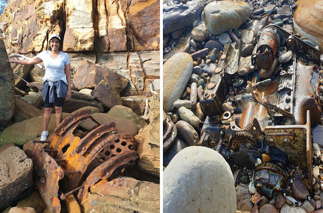
Maitland Bay is named after the paddle steamer SS.Maitland which sank after smashing into the rocks off Bouddi Point. Some remains of the wreck are still left at the eastern end of the beach and can be reached over the rocks at low tide. We decided to take the well worth challenge to hop over the rocks to see the wreckage which is more than 100 years old.
|
 |
| Hopping over the Rocks to Reach SS Maitland Wreckage |


Comments